Hill Top and Coal Hollow Fire Update: 8/10
Coal Hollow and Hilltop Fire Information
August 10, 2018 Morning Update
Contact Fire Information: 435.427.0846 or 435.427.4849
Email: 2018.CoalHollowFire@firenet.
Yesterday afternoon, officials sent an emergency evacuation alert to a much broader audience than intended. An increase in visitors to InciWeb and a large volume of calls to the fire information line caused both of them to go down. New fire information lines are in place this morning, and the website is working again. Thank you for your patience as fire managers and local officials work together to disseminate current information.
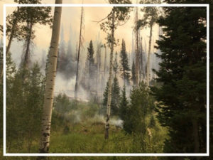
Smoky conditions were experienced throughout the vicinity yesterday. While inversions do limit fire behavior, they make for unhealthy air quality conditions. Those sensitive to the smoke, particularly the very young and the elderly, should limit outside activities. Consult a physician for more direction on your personal health effects.
Weather will remain hot and dry today. Atmospheric instability can lead to active fire behavior and rapid fire spread once the inversion lifts. Going into the weekend, there is an increasing chance for thunderstorms. Erratic winds make fire behavior very unpredictable. Visitors to public lands should check for closures and current fire information when making weekend recreation plans.
COAL HOLLOW FIRE – https://inciweb.nwcg.gov/
Location: 15 miles southeast of Spanish Fork, Utah
| Start Date | Cause | Size | Containment | Crews | Engines | Helicopters | Total Personnel |
| 8/4 | Lightning | 17,208 acres | 0% | 3 | 12 | 3 | 219 |
Current Situation: Fire behavior was moderated yesterday by the heavy inversion. Late in the afternoon, US 6 was closed for a couple of hours due to heavy smoke and the fire’s proximity to the road. It is open again, and the fire has not crossed the highway. Please travel carefully and with lights on through the canyon.
Firefighters are continuing to evaluate areas to directly work along the fire perimeter. In the northwest corner, they have been successful in constructing fireline and holding the fire. Along the northern and eastern edges, terrain and heavy fuels make direct engagement challenging. In these areas, a more indirect approach is safer, where firefighters can identify natural and manmade features to help slow the fire’s progression. Roads, rocky slopes, and green aspen stands can all be used as containment features.
Evacuation and pre-evacuation notices remain unchanged. Please visithttps://www.ready.gov/ for tips on preparing for evacuations. Knowing where you will go and what to take with you is critical to a safe and speedy evacuation. Utah, Carbon, and Sanpete County Sheriffs are engaged with Great Basin Team 4 to evaluate and expedite any additional evacuation changes.
HILL TOP FIRE – https://inciweb.nwcg.gov/
Location: 6 airmiles north of Fairview, Utah
| Start Date | Cause | Size | Containment | Crews | Engines | Helicopters | Total Personnel |
| 8/6 | Human | 1,861 acres | 61% | 3 | 25 | 1 | 167 |
Current Situation: Firefighters are making excellent progress containing the Hill Top Fire. There is fireline around the full perimeter. However, fire managers do not consider it contained until they are confident that potential fire activity will not spread past those lines, which in some places is roads. Sanpete County Sheriff is lifting evacuations for residents this morning at 10 o’clock. Those returning home will be under pre-evacuation notice, meaning that residents should stay prepared to evacuate if there is any change in fire conditions.