Coal Hollow Fire Update 8/13/18 0800
COAL HOLLOW FIRE UPDATE
Rocky Mountain Incident Management Team- Dan Dallas, Incident Commander
Information Center: 385-448-0929
Hours of operation: 7 a.m. – 9 p.m.
Website: https://inciweb.nwcg.gov/incident/6101
Email: 2018_utmlf_coalhollowfire@firenet.gov
August 13, 2018
8 a.m.
Current Situation: Afternoon thunderstorms caused a spike in fire activity on the Coal Hollow Fire south of Utah Hwy 6 yesterday. The fire crossed the highway, prompting the second closure of the major thoroughfare in less than a week. The fire is becoming established in lighter fuels in the Uinta-Wasatch-Cache National Forest and has the potential to move very quickly. Night crews monitored the fire through the night. Diamond Fork Canyon is under pre-evacuation order, although it is not in immediate danger. It is unclear at this time how long the highway road closure will be in place, but fire officials stressed that travel along the highway during this time could endanger public safety.
The thunderstorms sat directly over the fire causing winds from all directions. As conditions changed, crews disengaged and moved to safety zones until it was safe to continue working along the fire line. Yesterday’s planned firing operations to remove fuels and strengthen containment lines were not carried out due to the increase in fire activity.
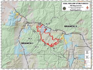
On the north side of the fire along Highway 6, in Division M, a combination of handline and dozer line was in place. Firefighters continued to improve the fireline in preparation for future firing operations, but made adjustments once the fire crossed Hwy 6. Moving to the east, in Division Q, a directly vertical column of smoke could be seen as the fire was impacted by multidirectional winds. Firefighters disengaged until the safety concerns were no longer present, and then re-engaged and continued to establish and improve a containment line. Structure protection was also implemented. The fire will remain active in the Clear Creek drainage and will continue to spread actively down canyon.
Division T on the southeast flank saw similar conditions as Division Q. One spot fire to the east was quickly suppressed. Dozers will be working along Starvation Road today and firefighers will continue constructing containment line. The fuel type is mainly conifer and aspen. Scooper planes and helicopters dropped water on Divisions Q and T until winds picked up and scoopers had to land for safety reasons. More helitack crews are ordered and will be arriving and working the fire today. In Division X, on the southwest side of the fire near Side Canyon, firefighters will be securing the fireline from the south edge of the fire to the midwest edge of the fire. Division Z on the west side was staffed with multiple night shift crews through the night. Today a combination of indirect handline, dozer line and a direct attack system where possible will be used to build containment lines.
Moving to the northwest side of the fire in Division J, hotshot crews worked to complete handline from the highway to the top of the ridge. Being a few hours away from securing the line, the fire spread northwest and crossed the highway in this area. Today hotshot crews will assess the situation and firing operations will be used as necessary to strengthen lines and remove fuels.
Note: Public Information Officers will stage at the information board in the Chevron parking lot in Fairview at 4 p.m. to answer questions.
Weather: Thunderstorms moving into the area today will likely produce measurable rainfall. Debris may be picked up by winds, and ash fall may be present in areas near the fire perimeter. Outflow winds will be possible, gusting up to 40 mph. Inversions will be weak due to the overnight cloud cover and added humidity, lifting early in the day.
Closures and Public Safety: US-6 is closed both directions from MP 187 (US-89 Junction) to MP 203 (Tucker). Mandatory and pre-evacuations remain in place for several areas in the fire vicinity. A map has been posted to utahfireinfo.gov showing the evacuation areas. The closure orders can be found on https://www.fs.usda.gov/mantilasal/ and https://www.fs.usda.gov/alerts/uwcnf/alerts-notices.
Fire Statistics:
Location: 15 miles southeast of Spanish Fork, UT Start Date: August 4, 2018 Size: 20,352 acres
Percent Contained: 4 Total Personnel: 575 with more resources arriving Cause: Lightning
Resources Include: 4 Type 1 hand crews, 3 Type 2 hand crews, 6 Type 2 initial attack, 26 engines, 4 dozers, 6 water tenders, 4 helicopters, 2 CL-415 Scoopers, 2 air attack platforms, and overhead/support personnel