Coal Hollow Fire AM Update 8/22/18
Coal Hollow Fire Update
Rocky Mountain Incident Management Team- Dan Dallas, Incident Commander
Information Center: 385-448-0929
Hours of operation: 7 a.m. – 9 p.m.
Website: https://inciweb.nwcg.gov/incident/6101
Email: 2018_utmlf_coalhollowfire@firenet.gov
August 22, 2018, 8 a.m.
NOTE: All evacuation zones have been lifted with the exception of Zone 1, which is adjacent to the fire perimeter. All forest service closures remain in effect.
A public meeting will be held in Fairview on August 23 at 6:00 p.m. at the Peterson Dance Hall (65 S State St, Fairview, UT 84629). Representatives from the Rocky Mountain Incident Management Team will be on hand to answer questions about the status and future plans for managing the Coal Hollow Fire.
Current Situation: The Coal Hollow Fire received wetting rain over the fire area on Tuesday, with associated cloud cover, higher humidity, and cooler temperatures greatly reducing fire behavior. Tuesday’s higher relative humidity allowed firefighters to improve lines and bring containment to 57%. The modest increase in acreage has come largely from data provided by an infrared flight over the fire on Monday evening, giving us a more accurate picture of the fire’s perimeter. Although the rain has moderated fire behavior, it has not put the fire out as heavier fuels will continue to smolder. The rainfall has provided opportunities for the fire crews to take a more direct approach to containment.
In Division M, crews went direct on Tuesday, establishing more containment line and moving east to tie into Division Q. In Division Q, on the western side of the fire, work on the containment line along Starvation Road will be completed and crews will begin working on rehabilitating the area and backhauling equipment.
In Division R and T, to the southeast, the containment line has been tied in all the way to the break between the divisions.
In the southwest area of the fire, Division X, construction of indirect, direct hand and dozer line has been ongoing along Lake Fork Road. A hotshot crew will continue this work today. In Division Z, work along the Lake Fork Road continued removing fuels along the road using chippers to reduce downed vegetation.
In the northwest, Division J, a helitack crew had been working on completing line down to Lake Fork Road. This Division will be unstaffed on Wednesday.
Weather: Rain showers and thunderstorms moved over the fire Monday night and most of Tuesday morning, producing about a half inch of rain over the entire fire. Small debris flows were reported in most of the drainages on the north side of the fire. The chance of thunderstorms continues Tuesday night through early Thursday. Gusty winds will again accompany the thunderstorms. High pressure will start to build back in late Thursday, leading to a drier forecast and temperatures closer to average for late August.
Information Briefing: Tomorrow is the last daily public information briefing that will be held at the info board at the Fairview Chevron, located at the Junction of Hwy 31 and Hwy 89 at 4 p.m.
NOTE: The Manti-LaSal National Forest closure order remains in effect at this time and can be found at https://www.fs.usda.gov/mantilasal/
Fire Statistics
Location: 15 miles southeast of Spanish Fork, UT Start Date: August 4, 2018
Size: 29,912 acres Total Personnel: 555 Cause: Lightning
Percent Contained: 57%
Resources Include: 2 Type 1 hand crews, 7 Type 2 hand crews, 30 engines, 4 dozers, 12 water tenders, 4 helicopters, 1 fixed wing air tankers, 1 air attack platforms, 2 masticators and overhead/support personnel
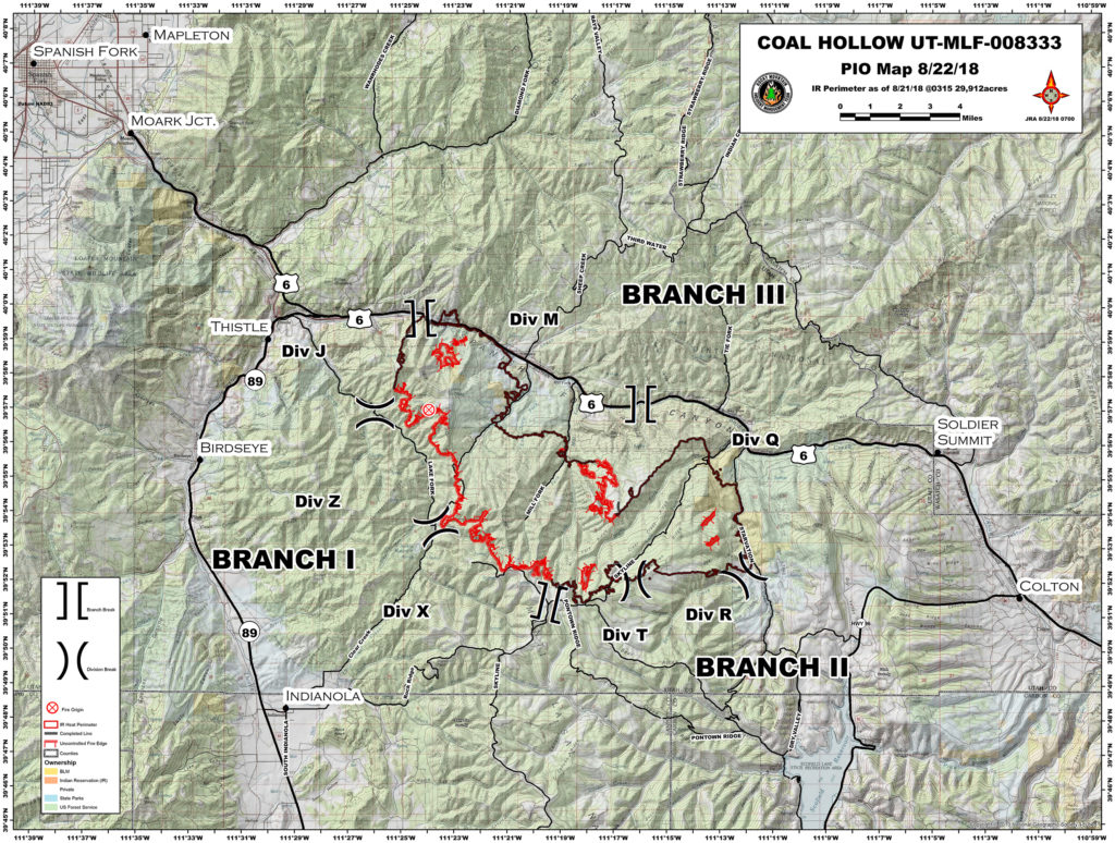
Coal Hollow Fire Updated Perimeter Map 8-22-18
Coal Hollow Fire Updated Evacuation Map 8/22/18