9/27 Mirror Lake Complex Update
Fire Information Line: (208) 495-4228 (8 a.m. – 8 p.m.) | Email: 2018.MirrorLakeComplex@firenet.gov
Facebook: U.S. Forest Service Uinta-Wasatch-Cache National Forest
Inciweb: https://inciweb.nwcg.gov/incident/6223/
| Fire | Start | Cause | Size
Ac. |
%
Contained |
Crews | Helicopter | Engines | Personnel |
| Mirror Complex | 2,310 | 19 | 5 | 5 | 5 | 204 | ||
| Murdock | 8/28 | Lightning | 1,662 | 21 |
The Murdock and Slate fires are sharing resources. |
|||
| Slate | 9/23 | Lightning | 631 | 17 | ||||
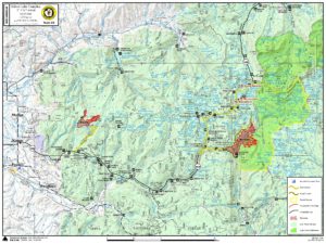
Summary: On Wednesday, the Murdock Fire grew 634 acres to the east, reaching the bottom of Marsell Canyon, just west of the High Uintas Wilderness boundary. To ensure public and firefighter safety, the Uinta-Wasatch-Cache National Forest is implementing an area closure. The Highline Trail, Naturalist Basin, Four Lakes Basin, East Fork Duchesne River Trail along with the Murdock Basin, Broadhead Meadows, Lost Creek Campground, Fehr Lake Trail, Mirror Lake Campground, North Fork Duchesne River Trail and Mirror Lake trails are CLOSED. Additionally, all areas on the south side of Utah State Route 150 (Mirror Lake Highway) between mile marker 22 and 35 are closed.
Wednesday, an unmanned aerial system (drone) was illegally flying along the Mirror Lake Highway (Hwy. 150) near the helibase supporting the Murdock wildfire. This area is within the Mirror Lake Complex Temporary Flight Restriction. While the siting did not interrupt air operations this time, the five helicopters supporting the Mirror Lake Complex will stop all activity if anyone sees a drone within the temporary flight restriction. To learn where the airspace is, visit: http://tfr.faa.gov/save_pages/detail_8_7103.html
Weather: Today will be a little more windy, warmer and drier than Wednesday. Clear skies will dominate the viewshed and allow for active fire behavior on the Murdock Fire.
Today: The Murdock wildfire is burning dead and down lodgepole pine trees and small aspen stands. As it burns, it is producing a smoke column that is visible from Kamas, Utah, 22 miles west of the fire. Firefighters anticipate similar fire behavior the next few days due to the fire’s alignment in the Murdock Basin drainage where high wind funneling through the canyon is driving it towards the High Uintas Wilderness. Firefighters anticipate the fire behavior to stay the same so long as very dry and windy conditions persist. There are no structures currently at risk.
Firefighters are working in the Mirror Lake Campground area removing hazardous trees, and limbing trees in the event the Murdock fire begins threatening the area. Firefighters are stacking the woody debris along the roadside where a chipper will begin chipping today and over the next few days. For public and firefighter safety, all public access to Mirror Lake and Lost Creek campgrounds are closed.
Two hand crews are working on the north end of the Slate fire. They are using pumps and hoses to extinguish hot spots that continue to flare up. Firefighters are making progress containing this area and anticipate another three to four days before that section can be safely contained. On the south flank, a small smoke is visible from the Mirror Lake Highway. This spot does not pose a risk to the highway or other infrastructure in the area.
National Forest Trail and Road Closures are in place.
Murdock Fire: A temporary area closure order is in effect. See the area closure map for a description of this area: https://inciweb.nwcg.gov/incident/article/6223/48368/
Slate Fire: Yellow Pine Trail (Trail #240) is closed. Smoke may be visible from Highway 40 and Highway 150 around the Slate Creek and Yellow Pine areas, especially in the late afternoon.
Map