#CoalHollowFire 27 August 2018
Date Started: August 4, 2018 Location: 15 miles southeast of Spanish Fork, UT
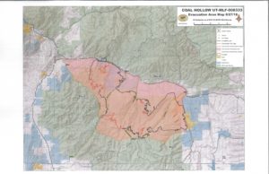
Cause: Lightning Total acres: 29,912 Containment: 80% Total Personnel: 246
August 27, 2018
FIRE SUMMARY
Coal Hollow Fire crews continue fire suppression on the southwest perimeter and rehabilitation of fire lines.
Yesterday, high southwest wind gusts produced some hotspots on the line in Division T, but fire crews were able to contain them with the aid of helicopters. Today high northwest wind gusts may produce some reignition of unburned fuels in the interior and could drive smoke toward the Hwy 6 corridor.
Roadcrews will remove signs from Hwy 6 today, but travelers should still use caution if traversing the area.
Fire lines, along the Hwy 6 corridor and in Divisions Q and T at the north and east edge, are in good shape as fire crews continue to rehab and seed the lines. In Division Z, crews continue fire suppression efforts, improving lines with chipping operations. Chipping operations consist of crews utilizing wood chippers to reduce the amount of fuels, such as brush and downed trees, along existing fire lines.
CLOSURES
Open
Starvation Road, the southern and western areas adjacent to the fire, including Bear Ridge Road, Fish Creek Ridge Road and Skyline road south of the Bear Ridge Road junction are open.
Closed
North Fork Road is closed along the western fire edge and Skyline Road from Hwy 6 south to the Bear Ridge Road juncture. Road blocks are still in place at closure areas.