9/30 Mirror Lake Complex Update
Fire Information Line: (208) 495-4228 (8 a.m. – 8 p.m.) | Email: 2018.MirrorLakeComplex@firenet.gov
Facebook: U.S. Forest Service Uinta-Wasatch-Cache National Forest
Inciweb: https://inciweb.nwcg.gov/incident/6223/
| Fire | Start | Cause | Size Ac. |
% Contained | Crews | Helicopter | Engines | Personnel |
| Mirror Complex | 5,137 | 17 | 5 | 5 | 5 | 204 | ||
| Murdock | 8/28 | Lightning | 4,475 | 10 | The Murdock and Slate fires are sharing resources. | |||
| Slate | 9/23 | Lightning | 662 | 34 | ||||
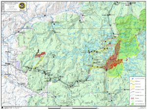
Road Closure: The Utah Highway Patrol is closing the Mirror Lake Highway (Highway 150) from Murdock Basin Turnoff (Mile Marker 22) to Ruth Lake Campground (Mile Marker 38) for public and firefighter safety. Please avoid the closed area.
Summary: Red flag conditions led to the Murdock fire making a 2.5 mile run to the northeast in the Duchesne River Drainage Saturday, burning 1,525 acres. It was stopped by the rocky cliff band near Mount Agassiz, located in the High Uintas Wilderness. The fire is 1.5 miles east of Highway 150 (Mirror Lake Highway), however due to smoke impacts and the abundance of people in the highway corridor, the Utah State Highway Patrol is closing the highway.
On Saturday, firefighters spotted a drone along the Mirror Lake Highway between mile markers 7 and 8. This did not interrupt air operations, although this is the second incursion that has occurred in the restricted airspace. Please DO NOT fly drones near the fire area.
Weather: Another windy day is expected across the fire areas today with gusts over 30 mph. There is a chance of thunderstorms over the area that may produce outflow winds reaching 50 mph. These conditions will likely generate aggressive fire behavior again today, especially on the Murdock fire.
Today: For the past week, firefighters have been taking actions to minimize fire impacts to the Mirror Lake Highway and the infrastructure along it, including Mirror Lake. The fire is burning in very steep drainages with 90 percent dead, down and standing lodgepole pine trees and some aspen stands. These very dangerous conditions are preventing firefighters from safely working directly near the fire area. Instead, they are leveraging the bare granite Murdock Basin cliffs to contain the fire on its west flank while the southern flank remains contained.
National Forest Trail and Road Closures are in place.
Murdock Fire: The Highline Trail, Naturalist Basin, Four Lakes Basin, East Fork Duchesne River Trail along with the Murdock Basin, Broadhead Meadows, Lost Creek Campground, Fehr Lake Trail, Spring Creek Trail Mirror Lake Campground, North Fork Duchesne River Trail and Mirror Lake trails are CLOSED. Additionally, all areas on the south side of Utah State Route 150 (Mirror Lake Highway) between mile marker 22 and 35 are closed. See the area closure map for a description of this area: https://inciweb.nwcg.gov/incident/article/6223/48368/
Slate Fire: Yellow Pine Trail (Trail #240) is closed. Smoke may be visible from Highway 40 and Highway 150 around the Slate Creek and Yellow Pine areas, especially in the late afternoon.